Forecasters are also monitoring the same storm that caused flooding in Florida in recent days, which is unlikely to become a tropical storm as it moves north and northeast off the East Coast this weekend.
Storms possible in southern Gulf of Mexico next week
The southern Gulf of Mexico (near the Yucatan Peninsula) is the area most likely to develop tropical cyclones.
Rain and thunderstorms near Central America are forecast to solidify into a low pressure system over the Bay of Campeche by early next week.
Weather models show conditions are gradually shaping up for a hurricane to strengthen, with the National Hurricane Center giving it a 50% chance of becoming a tropical storm or severe storm within the next week.
Strong high pressure over the United States will tend to limit how far the storm can move north, but it should be monitored from the Veracruz area of the Mexican coast north to South Texas. There is a lot of uncertainty as the storm has not yet developed, but unusually warm waters could help it develop.
If the system brings heavy rains to Mexico, it could be potentially beneficial given the widespread drought in the country.
Systems off the East Coast
The same severe weather area that dumped 15 to 25 inches of rain on South Florida and prompted emergency declarations is drifting northeast off the southeast coast.
The possibility of heavy rainfall to the south means areas south of Miami are at increased risk of flooding for another day, with parts of the region potentially receiving several more inches of rain.
As the system moves north up the East Coast and offshore, the National Hurricane Center predicts a 20 per cent chance of developing into a tropical depression or storm. It could be strengthened by the warm waters of the Gulf Stream. The storm does not pose a major threat to land, but it could bring gusty rain to parts of Atlantic Canada this weekend.
As it moves northward, strong high-altitude winds will affect the storm, likely limiting its development.
Abnormally Warm Water is a Warning Sign
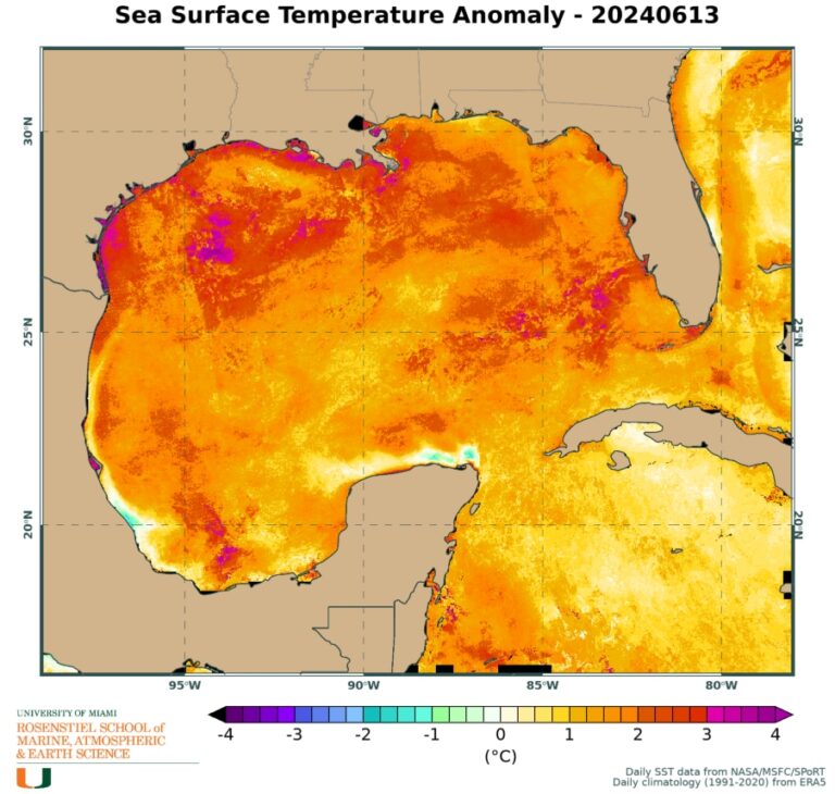
As has been the case for over a year now, much of the world’s oceans are significantly warmer than normal, including near the United States and in areas that are on the brink of tropical storms and hurricanes.
Water temperatures in much of the Gulf of Mexico have risen into the mid-80s Fahrenheit, with some areas reaching as high as 90 Fahrenheit.
These temperatures will be at least 3 degrees above average, and in some places as much as 7 degrees or more.
Despite the warm waters, no named storms have yet formed, making this the latest start to the Atlantic season since the first storm was named on July 1, 2014.
Experts continue to predict a very active hurricane season, due in large part to both extremely warm ocean waters and the end of El Niño and the possible emergence of La Niña, weather patterns that are very favorable for Atlantic storms.
Earlier this week, hurricane forecasters at Colorado State University reaffirmed their predictions for April to produce 23 named storms, 11 hurricanes, and five major hurricanes, compared with an average season of 14 named storms, six hurricanes, and three major hurricanes.

