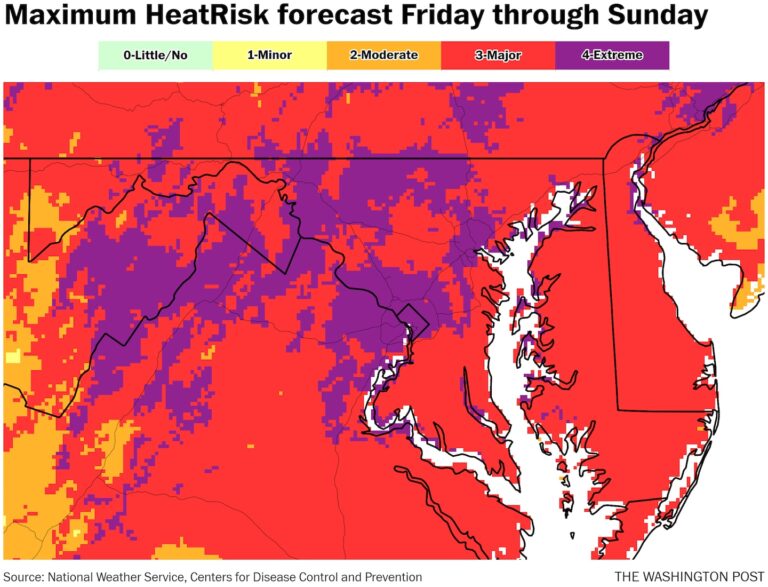
On a scale of zero to four, the heat risk for the region is expected to rise from level 1 (mild) on Thursday to level 4 (extreme) by Sunday, according to the National Weather Service. The heat risk scale takes into account how extreme and long the heat will last, as well as how much of a threat it is expected to pose to human health.
If it does top 100 degrees, it will be the first time since 2016. Washington has gone nearly eight years without a 100-degree day, the longest streak since the 1970s and the fifth-longest on record.
Extremely hot days and scorching nights will lead to increased health risks over the next few days. A heatstroke emergency plan in place in the city until Friday is expected to be extended through at least Sunday. Officials recommend staying hydrated, taking frequent breaks if exercising or spending long periods outdoors, and finding air-conditioned places to cool off. People who work outdoors, the elderly and the homeless are especially vulnerable to extreme heat.
Let’s see how hot it gets
Highs have been in the low 90s Fahrenheit for the past few days, but temperatures will start to warm up on Friday and will peak this weekend.
upon FridayHighs will be mostly in the mid 90s F. Cooler areas north and west of the Beltway may only get up to 90 F. Humidity will still not be too bad.
Saturday This will be the hottest day in years, but that title may only last a short time. Afternoon temperatures will rise into the mid to high 90s F, with most of the area in the upper 90s F. Humidity will be high (dew points near 70 F), making it feel 5 to 8 degrees warmer. Localized cold fronts are possible, but don’t plan for them.
Sunday Most places will likely be a degree or two hotter than Saturday. Forecasters are calling for 100 degrees in Washington, DC, and most areas along Interstate 95 from Richmond to Philadelphia. As with Saturday, high humidity will make it feel like 105 degrees. There will also be a higher chance of storms developing later in the evening, but probably after temperatures have peaked.
Temperatures will also get increasingly uncomfortable over the weekend, possibly breaking records. On Sunday, Washington’s low could drop to as low as 80 degrees, which would be the warmest morning low since July 2019.
Heat advisories, which are issued when the heat index is forecast to reach at least 105 degrees, could be in effect for both days of the weekend, according to the weather service serving the region.
A heat wave warning would be issued if the heat index is predicted to reach at least 110, but that is not currently expected.
High temperatures on Friday are expected to be in the mid-to-low 90s Fahrenheit, just shy of records in most locations. Dulles International Airport could get close, hitting a record of 98 degrees compared to a forecast of 96 degrees.
The odds of a record increase on Saturday, but many of the rankings could again fall just short as they are all near or above 100. The forecast for Dulles is 99, with a record of 99. In the District, the forecast of 99 equates to a record of 101.
Sunday looks the most likely day to reach 100 and set some records, with Washington, Dulles and Baltimore all expected to break records with highs reaching around 100.
Long periods of temperatures above 90 degrees
Washington, DC, has seen four consecutive days with temperatures at or above 90 degrees, and forecasters say that could continue for a while. If that streak continues for eight days or more, it will be the longest streak since 2020, when temperatures hit 20 degrees, the second-longest streak on record.
This year has already seen a big change in the number of days with temperatures above 90 degrees: Until last weekend, the area had only recorded one day with that temperature, but now that number has reached seven, which is about average for this time of year.
High temperatures above 90 degrees are likely to continue through at least the middle of next week.
A brief dip in the jet stream could keep temperatures in the region closer to average (mid to upper 80s F) for a while afterward. This could result in sustained highs above 90 F, but the heat could return after a brief cooling period.
As we move into July, summer heat will return to many parts of the country, with higher temperatures possible along the Mid-Atlantic coast. The National Weather Service predicts that much of the country will likely experience above-average temperatures next month.

