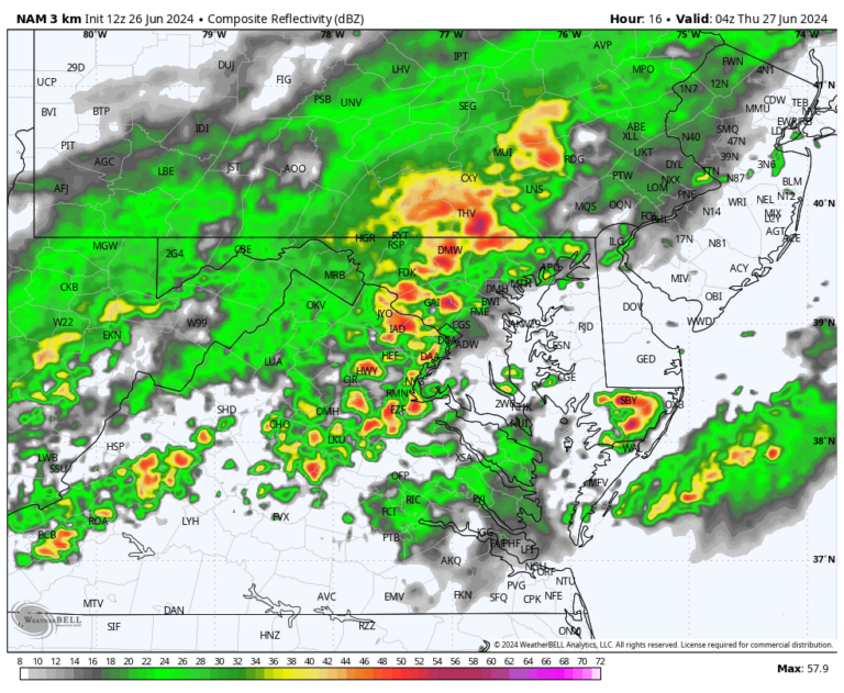
Storms may move from west to east during the mid to late afternoon. Storms that develop during this time will most likely become severe storms, but there is uncertainty as to how long the storms will develop. There is an increased chance of more storms developing Wednesday evening, but there is uncertainty as to whether there will be enough energy in the atmosphere for the storms to strengthen and become severe.
- timing: Multiple rounds are likely to take place between mid-afternoon and Wednesday night.
- 3pm to 8pm: Locally strong to severe storms.
- 8 PM to 3 AM: Scattered storms possible, some of which could be strong to severe.
- After 3am: Light rain and storms possible.
- interval: 30 to 60 minutes, but longer if multiple storms pass through.
- Most likely impacts: Frequent lightning, localized gusts of wind, heavy rain and hail.
- Possible impacts: Isolated flooding, numerous damaging wind gusts, large hail, and brief, weak tornadoes.
- Please note the following: A storm capable of dumping 1 to 2 inches of rain in just 1 to 2 hours, forming a bow-shaped storm on radar, with localized wind gusts near or exceeding 70 mph.
Wednesday’s scenario includes an approaching cold front in the lower atmosphere and disruption of upper air currents, both of which could lead to atmospheric instability across the Mid-Atlantic.
Weather models suggest there could be two or more distinct rainfall and storm events.
The first batch is less certain. Subtle wind shifts in the western highlands and downwind of the Appalachians could result in it possibly happening around 3-5pm, and possibly passing near the Beltway and I-95 corridor around 5-7pm.
Further storms are likely ahead of the front late Wednesday night and could last for several hours, with the heaviest rain and most severe thunderstorms occurring between 9pm and midnight, and lingering rain likely to continue through the night.
How unstable the atmosphere becomes and how prone it is to developing severe storms will depend in part on the amount of cloud cover in the afternoon, but given the intense heat and abundant moisture in the atmosphere, a moderate amount of “storm fuel” is likely. Increased upper-level winds, especially in the evening, could help storm cells organize into longer-lasting clusters.
The main dangers include the destructive wind concentrations caused by downbursts – when thunderstorm winds blow downward and fan out as they reach the ground – and the violent lightning that accompanies powerful storms.
Repeated passes of the storm over the next few hours may cause flooding, especially in the evening. Some places are expected to receive around 2-3 inches of snowfall. Dry spells in nearby places cannot be ruled out.
Rainfall in June, despite typically being the wettest month of the year, was about 3-4 inches below average and less than 25% of typical rainfall in Washington, DC and the South. Drought conditions re-emerged in the region last week and are likely spreading given the recent hot and dry conditions.

