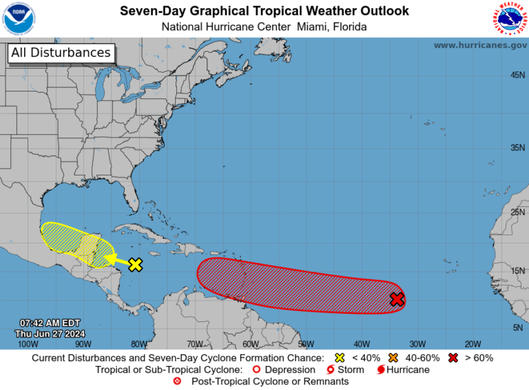
Forecasters estimate there’s a 70 percent chance that the disturbance, currently halfway between South America and Africa, will develop into a tropical depression or storm, and weather models are optimistic about its long-term outlook, with some suggesting it could develop into a hurricane as it moves slowly westward toward the Caribbean.
Another storm in the western Caribbean is expected to bring rain and gusty winds to Mexico’s Yucatan Peninsula through the weekend.
The 2024 Atlantic hurricane season is just getting started, historically not peaking until mid-September on average, and forecasters are concerned that unusually warm water temperatures and relaxed high-altitude winds due to the growing La Niña weather system could result in a more active hurricane season than usual.
What you need to know about a system that could intensify this weekend
The more notable of the two systems is currently located several hundred miles southwest of the Cape Verde Islands in the Atlantic Ocean, halfway between French Guiana in South America and Sierra Leone in Africa.
The hurricane center estimates there is a 70 percent chance the storm will strengthen, writing that “a tropical depression or tropical storm is likely several hundred miles east of the Windward Islands this weekend.” The hurricane is moving west at 15 to 20 miles per hour.
Infrared satellite images show severe thunderstorms swirling and blooming. Already, the scatterometer, a satellite-based sensor that measures wind speed, suggests the storm has sustained winds of 35 mph, slightly weaker than tropical storm force. Because it doesn’t yet have a center, there’s no risk of it becoming a named storm today.
Weather models suggest that the system will gradually but steadily organize and strengthen over the next few days. There are two mitigating factors that will slow the expected strengthening.
- Saharan Layer (SAL) Or dust trapped in a layer of hot, dry air about a mile above the ground. This layer holds back the warm, moist air below, preventing air parcels from rising vertically to form thunderstorms. Invest 95L is south of the Saharan air layer, but the SAL could put the brakes on it organizing more quickly.
- shear, Or wind direction changes with height. Mid-Atlantic shear tends to be a hindrance to storms in the Atlantic’s Main Development Region (MDR) at this time of year. (This is an imaginary rectangle in the tropical mid-Atlantic within which many long-distance hurricanes develop.) The shear is expected to weaken over the next few days, but models often underestimate the strength of mid-Atlantic shear. As a result, Invest 95L may not strengthen more strongly until it approaches the Windward Islands late Sunday.
However, it could develop into a hurricane if it reaches the Lesser Antilles, at which point conditions become more favorable for a strengthening storm, and any event in the Caribbean could eventually have a land impact, so keep an eye on it.
The second system of note
Showers and thunderstorms continued to occur in the western Caribbean Sea east of Nicaragua and Honduras. Convective (shower and thunderstorm) activity was high, but no significant circulation was observed.
The strong mid-level winds currently spreading over the Caribbean Sea will hinder the ability of tropical disturbances to organize. Ironically, tropical disturbances require near-calm conditions at multiple levels of the atmosphere to integrate. Too much wind would throw the nascent disturbance out of balance, causing it to dissipate prematurely.
The National Hurricane Center has designated the disturbance “Invest 94L” and estimates it has a 30 percent chance of eventually maturing.
The storm is expected to move near Cancun on Saturday and near the Bay of Campeche on Sunday, bringing scattered heavy rains before quickly weakening.

