Hurricane watch issued as Tropical Storm Beryl approaches Caribbean
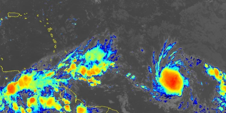
Tropical Storm Beryl is forming east of the Caribbean islands in the tropical Atlantic Ocean and is expected to strengthen into a hurricane as it moves westward over the next few days.
The National Hurricane Center is currently tracking Hurricane Beryl, less than 1,000 miles east in the Caribbean Sea.
The second named storm of the 2024 Atlantic hurricane season quickly strengthened from a tropical depression to a tropical storm to a hurricane in less than 24 hours, also helped by atmospheric conditions.
According to the latest report from the National Hurricane Center, maximum sustained winds were 75 mph and the minimum central pressure was just under 992 mb.
The cyclone was classified as a Category 1 hurricane on the Saffir-Simpson hurricane wind scale, making it a rare event for the Mid-Atlantic in June.
The average date for the first hurricane to form in the Atlantic basin is August 11, so this season is moving ahead of the usual schedule.
Water temperatures in parts of the Central Atlantic are similar to typical values for August and September, and the hurricanes are smaller, avoiding the effects of Saharan dust and strong upper-level winds.
A hurricane warning has been issued for Barbados, with neighbouring islands including St. Lucia, Grenada, St. Vincent and the Grenadines, Martinique, Dominica and Tobago also on alert.
Where are the Lesser Antilles, Windward Islands, and Leeward Islands?
What is the forecast for Hurricane Beryl?
Destructive winds considered tropical storm or hurricane strength can only extend up to 45 miles from the center.
The forecast track will see the storm move in a westward or west-northwestward direction over the next 72 hours, meaning only the Windward Islands will be affected by destructive gusts of wind.
The NHC’s latest forecast calls for the hurricane to become a major Category 3 hurricane, with sustained sustained winds reaching more than 120 mph in the eastern Caribbean.
In addition to hurricane-force winds, heavy rains will drench islands, and current forecasts predict Beryl will bring 3 to 6 inches of rain to Barbados and the affected Windward Islands, causing localized flooding.
The NHC has raised its storm surge forecast, predicting a “life-threatening” storm surge in land-bound areas that could raise water levels by up to 5 to 7 feet above normal tides.
BERYL TRACKER: Live forecasts, tropical weather alerts, spaghetti models and more
Will Beryl have an impact on the US?
The closest US territories to the storm are the US Virgin Islands and Puerto Rico, but neither are under a warning.
The FOX Forecast Center expects the main impacts to remain south of the islands, but the possibility of passing rain clouds cannot be ruled out.
It remains to be seen whether the hurricane will threaten the continental U.S., but if it does, it will likely be in a different form.
“After Beryl reaches the Caribbean, the forecast becomes unclear. Is there a chance it will eventually reach the Gulf of Mexico? Yes, “The storm is threatening to hit the area,” said FOX Weather hurricane expert Brian Norcross.“But it’s not worth thinking about, there are too many variables in play.”

