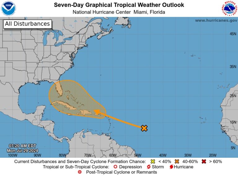
The National Hurricane Center estimated Monday that the disturbance has a 50 percent chance of developing into a tropical depression or storm. If it reaches storm strength, “Debby” would be next on the 2024 Atlantic storm list.
Computer models predict the storm will remain weak for the next four to five days, but some models suggest it could intensify rapidly once it gets close to the United States.
This system could mark the beginning of a period of increased Atlantic storms. Experts continue to warn that the 2024 Atlantic hurricane season will be very active. In fact, researchers at Colorado State University estimate that it will produce 25 named storms, including three so far.
This season has already featured Beryl, which became the fastest-forming Category 5 hurricane on record before striking Houston on July 8, battering the city with winds of 80-90 mph and about a foot of rain.
Where are the systems of concern and how strong are they?
On Monday, the storm was located about 700 to 800 miles east of the Lesser Antilles and was moving slowly west. Satellite images showed it to be erratic and turbulent, with only a few light showers and thunderstorms.
This was because strong upper-level winds to the north of the disturbance made it unbalanced, and dry air at high altitudes enveloped the disturbance, weakening its structure and ability to form thunderstorms.
What are the chances of a tropical storm or hurricane?
In the short term, chances of this system developing are very limited. Strong winds and dry air masses will continue to hinder development of this system over the next 3-4 days. By the end of the weekend, the system will meander near the Bahamas or the Dominican Republic and Haiti, possibly approaching Cuba.
High-level winds will weaken and possibly strengthen on Friday and Saturday as updrafts begin to spread into the western Atlantic, Gulf of Mexico and Caribbean Sea.
The updrafts could help the storm strengthen unless it weakens as it passes over land in the Dominican Republic, Haiti, and Cuba.
If the system persists long enough to reach the Gulf of Mexico or southwest Atlantic, it will be at increased risk of becoming a named storm or hurricane, although some computer models indicate the system is not cohesive enough to pose much of a threat in the West.
Where will this potential storm lead?
There is a wide range of possibilities for where this system will ultimately go. The main influence on its path is the Bermuda High, a large semi-stationary high pressure system over the central Atlantic. A clockwise veer around this high pressure system will push the system westward and eventually further north. However, where and when this northward veer will occur is difficult to predict this many days in advance.
What areas need to be monitored most closely?
The Lesser Antilles and Puerto Rico are not expected to be significantly affected as this storm is unlikely to strengthen significantly before reaching Puerto Rico. Cuba, the Dominican Republic, the Bahamas, Florida, and the Carolinas should be closely monitored.
Are there any other threats?
Beyond this system, there are no other areas of concern in the tropics, but the Atlantic could become more congested in mid-August, when a circulating weather pattern called the Madden-Julian Oscillation boosts updrafts over the tropical Atlantic.

