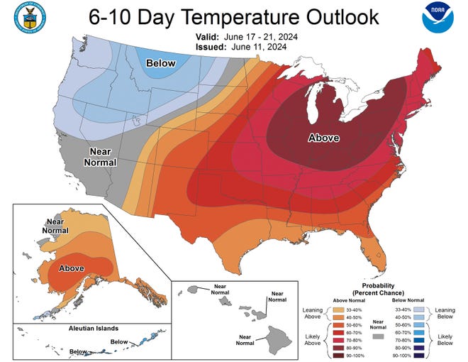
The heat wave is expected to spread from the Central Plains to the eastern U.S. on Monday and linger across the Northeast through at least midweek, as a winter storm dumps snow on Montana and Idaho, according to the National Weather Service.
As of 8 a.m. ET on Monday, more than 59 million people in the U.S. were under heat watches, more than 5 million were under heat warnings and more than 16 million were under heat watches.
The National Weather Service’s heat danger map for Monday showed a wide swath of red extreme heat from West Virginia to Kansas. Parts of Iowa, Illinois and Missouri had the extreme heat danger rise to purple, indicating extreme heat with little or no overnight temperature drop, which could impact heat-sensitive industries and infrastructure, the National Weather Service said.

AccuWeather meteorologist Tom Caines expects heat to dominate headlines this week in the central and eastern parts of the country.
“The Midwest, the Ohio Valley, the Great Lakes, the Mid-Atlantic and the Northeast – these areas will see temperatures above 90 degrees for the first time this year,” he told USA Today on Sunday.
Weather forecast for the coming week:Extreme weather week hits US: From scorching heat to snow. Yes, snow.

Snow expected in northern Rockies amid winter storm warning
A heat wave is expected in the Midwest while frost is expected further west.
Temperatures could drop into the 20s in parts of the northern Rockies. A winter storm warning was issued for western Montana and eastern Idaho on Sunday, meaning snow could fall in the region early next week.
Forecasters warned that “heavy, wet snow” could cause power outages, down trees and make dirt roads dangerous, according to the National Weather Service in Missoula, Montana.
By Monday morning, parts of the region’s higher elevations were already covered in snow, including the 7,000-foot-high Lost Trail Pass that runs along the Montana-Idaho border, according to photos shared by the National Weather Service.
The summer storm could dump more than a foot of snow in some areas, making mountain roads “slippery” and “difficult” to travel on Monday night into Tuesday, according to AccuWeather forecasters.
Severe thunderstorm watches were issued for Iowa, Minnesota and Wisconsin on Monday.
Much of the country is under a heat warning, while more than one million people are under a severe thunderstorm watch for Monday.
Heavy rain and severe thunderstorms are possible across the North Central Plains on Monday, then move north into the northern Plains and northern Minnesota late Monday night and into Tuesday, according to the NWS.
The thunderstorms are expected to move farther south from the Central Plains into the northern Midwest Tuesday night into Wednesday morning, according to the NWS.
Nationwide Weather Warnings and Advisories
Gabe Haouari is a national trend news reporter for USA Today. You can follow him on X. Gabe Haouari Or email me at Gdhauari@gannett.com.

