Storms hitting upper Midwest could lead to record river levels
Multiple heavy rains have caused extremely soggy ground and are expected to cause major flooding along rivers across the Midwest over the next few days.
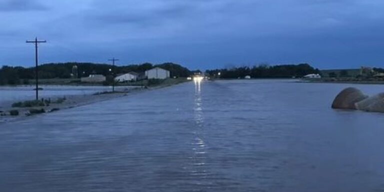
Des Moines, Iowa — Multiple rounds of heavy rain and thunderstorms are threatening major flooding in the upper Midwest on Saturday and could cause record-breaking river flooding into early next week, with swollen rivers already bursting their banks in Iowa and forcing emergency evacuations.
As a low pressure system slowly moves across the upper Midwest on Saturday, widespread rainfall of 2 to 4 inches is expected through Saturday afternoon, with some storms expected to produce more than 5 inches of rain.
Rainfall rates in the most intense storms are expected to exceed one inch per hour, which could cause life-threatening flash flooding and rapid river flooding if the storms remain over the area.
NOAA’s Weather Prediction Center has rated the risk of flash flooding at a level 2 out of 4 for much of southern Wisconsin, including Milwaukee and Madison, on Saturday.
However, the rain is falling on areas that are already extremely waterlogged after multiple heavy downpours lashed the region, raising concerns about widespread river flooding.
Radar estimates suggest that 8 to 12 inches of rain has already fallen in South Dakota and Minnesota over the past few days, and before the ground has had time to dry, water is rushing into river basins, causing river levels to rise rapidly.
7 things you need to know about flash floods
Forecast models show dozens of rivers in southeastern South Dakota, northern Iowa and southern Minnesota are expected to reach moderate or major flood conditions.
Midwest River Level Forecast
According to the FOX Forecast Center, several river stations may record their highest water levels ever over the next few days.
Iowa’s river basins, located downstream of the heaviest rains, could be the worst hit, with rivers including the Big Sioux, Little Sioux, Ochaidan and Des Moines predicted to exceed record flood levels.
The West Branch Des Moines River basin is of greatest concern, according to the National Weather Service, where projected river flooding in some places could approach record flood levels and exceed those recorded in 1993.
Levee breach creates flood emergency in northern Iowa
Already rising river levels and heavy rains caused a levee to fail along the Rock River in Rock Valley, Iowa, early Saturday morning, triggering emergency evacuations and a flood emergency.
Flood watches, warnings and emergencies: Here’s the difference that could save your life
“We are sounding sirens (in Rock Valley),” the Sioux County Sheriff’s Office posted on social media. “This means evacuating your home if possible.”
Rock Valley city officials posted updated maps to the city’s social media accounts showing evacuation zones expanding as water levels rise, and the sheriff’s office reported that at least two bridges and a road had been washed away.
“Boats and emergency personnel are on the way from neighboring towns,” city officials posted on social media. “Anyone outside of the emergency evacuation zone should continue to stay home. Further evacuations are being planned and we will continue to highlight on the map areas of town that are expected to be evacuated.”
How floods can cause serious illness
A shelter was set up in a local church, but more help was needed.
“Farmers in the Rock Valley area, if it is safe to come to Rock Valley, please bring your tractors or loaders and help with the evacuation,” city officials called on the public.
Iowa Governor Kim Richards issued an emergency disaster declaration for Sioux County and deployed state resources to help Rock Valley and other flooded areas of Iowa.
In O’Brien County, Iowa, emergency response officials were also overwhelmed by widespread flooding and numerous rescue efforts.
“O’Brien County emergency responders performed multiple rescues of people trapped in vehicles that had been swept away,” county officials posted on social media. “Flooding has caused significant challenges for emergency crews attempting to reach the scene. County Road and Iowa Department of Transportation are working hard to set up barricades, but widespread flooding has stretched their resources.”
Severe weather poses further danger this weekend
Not only should people in the upper Midwest watch for dangerous flooding, but severe storms are also expected to move through the Midwest over the weekend.
Several major cities, including Chicago, Milwaukee and Des Moines, Iowa, could see severe storms with tornadoes, strong winds and large hail.
NOAA’s Storm Prediction Center predicts all of those cities are under a Level 2 out of 5 severe weather risk on Saturday.
“We think it’s going to start to really intensify between lunch and dinner on Saturday,” FOX forecaster Michael Estime said. “So if you have plans for a late lunch or early dinner, you’ll see (the storm) extend from Green Bay to Milwaukee and into Des Moines. Another round of heavy rain with strong to severe storms will hit Chicago after dark later this evening, then move south around Peoria, Illinois.”
On Sunday, the threat of severe weather will shift from the Midwest to the Northeast.

