CNN
—
After violent and destructive storms battered a wide swath of the central United States over the weekend, severe Memorial Day weather is expected to continue into Monday, although the threat of extreme impacts is reduced this time.
Severe storms ripped through several states, including Kentucky, Arkansas, Texas and Oklahoma, over the weekend, with powerful storms and suspected tornadoes killing at least 19 people, four of them children.
Images from the aftermath showed piles of rubble, damaged vehicles and destroyed buildings. High winds and rain downed trees and power lines, leaving more than 600,000 people in 12 states without power. The storm also forced the postponement of the 108th running Indianapolis 500 for about four hours on Sunday afternoon.
LIVE UPDATES: At least 19 killed in tornado storms that hit central US
Severe storms pounded parts of Kentucky overnight, causing damage in some areas, prompting Gov. Andy Beshear to declare a state of emergency early Monday. Phone lines in Bowling Green were down and police set up an alternative emergency number for people calling for help.
The National Weather Service in Paducah said it would send out at least two storm survey teams Monday to assess the damage.
Two storm-related deaths have been reported statewide — one in Mercer County and the other about 70 miles away in Louisville. As the storm moves eastward on Monday, its intense and extreme effects are expected to abate, providing some relief.
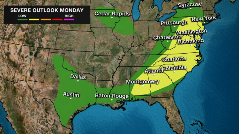
Heavy rain is expected to flood parts of the East Coast on Monday, and while the chance of tornadoes is much lower than those seen over the weekend, isolated tornadoes are still possible along the Interstate 95 corridor from Newark, New Jersey, south into the Carolinas.
East Coast Major Cities also face the threat of damaging winds, while parts of the south are set to experience scorching heat with the potential to break records as summer marks the unofficial start of the year.
The storm front will move up the East Coast by Tuesday evening, according to the National Weather Service’s Storm Prediction Center.
“This boundary will bring areas of rain and severe thunderstorms to parts of eastern Missouri and the Ohio Valley,” the center said.
The risk of severe thunderstorms has risen to Level 3 out of 5 for those areas and the Tennessee Valley through Monday morning, with associated dangers of frequent lightning, severe thunderstorm gusts, hail and some tornadoes.
“Parts of the Lower Mississippi River Basin and West Tennessee Valley will experience an increased risk of EF2 to EF5 tornadoes and hail greater than 2 inches high,” the Storm Prediction Center said.
Areas along the upper Mississippi River and upper Great Lakes basins, including parts of Wisconsin, also face the threat of localized flash flooding from heavy rainfall through Monday morning.
Heavy rain will also impact Memorial Day plans from the Mid-Atlantic to the Northeast, as there is a slight risk of excessive Level 2 or Level 4 rainfall in these areas Monday into Tuesday morning, which could lead to flash flooding in low-lying areas and urban areas.
High temperatures and an unseasonable heat wave are expected to make the Memorial Day holiday sweltering across much of the South, including South Texas, the central Gulf Coast and southern Florida.
A heat warning remains in effect for South Texas until Monday night, with further heat warnings and watches expected across the South.
Houston, New Orleans, Miami, Mobile, Alabama, Tampa, Florida, and Charleston, South Carolina are some of the areas that could experience extreme heat on Monday.
The center said some locations could experience record high or near record high temperatures, with heat index values exceeding 115 degrees Fahrenheit. The heat index — a measure of how hot the body actually feels — is expected to reach about 110 degrees Fahrenheit in Houston and 119 degrees Fahrenheit in Laredo on Monday, according to the National Weather Service in Houston.
Temperatures may not drop overnight in some areas, with overnight minimum temperatures expected to be 10 to 15 degrees above normal.
Such extreme and prolonged heat increases the risk of heat illnesses, including heatstroke, especially for vulnerable groups such as children, adults with underlying health conditions, pregnant women and outdoor workers.
The risk of extreme heat, the deadliest form of extreme weather, is becoming more prevalent as the planet warms due to human-induced climate change: During last year’s warm season, the rate of emergency room visits due to heatstroke increased by 20% compared to the previous five seasons.
CNN Meteorologist Eliana Hebert and CNN’s Joe Sutton contributed to this report.

