The storm will move south and calm conditions will prevail
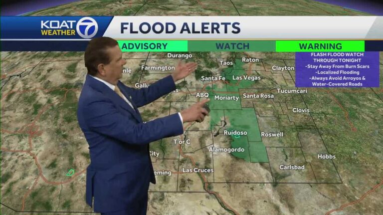
It will be centered this weekend Friday through Sunday from noon to 5 p.m. The monsoon storm will move into different parts of New Mexico. Chief meteorologist Joe Diaz shows where the monsoon storms will actually be less for a while in the Ruidoso burn area. This will continue for a couple of days, which is nice. It’s 93 degrees right now. It’s going to start off pretty hot in the evening, but it looks like it won’t rain, although there may be some showers or storms. Dry air will move into the eastern part of the state. Then the monsoon moisture will move westward. As I’m going to show you, the heat will continue into the afternoon. There’s no way around it. You can see the showers and thunderstorms starting up around the high country and then weakening and then pouring into the Ruidoso area one after the other. This is never a good thing. This flood watch will be in effect for the rest of tonight. There may be warnings in place tomorrow, but I don’t think it will be as active tomorrow in the Ruidoso area. The Ruidoso area is great. Moisture in the air can produce a lot of rain when a storm develops, especially with the lighter shades that you see here tomorrow. It looks like the moisture in the air that produces excessive rain is going to decrease a little bit. But as you can see over there, it’s still pretty much there. And then let’s look at Friday. I’m not saying we won’t have storms everywhere, but we won’t have the amount of moisture that we’ve had over the past few days. The path that we’re on will be dry in the morning because we’re in Ruidoso now, and dry in the afternoon. Yeah, there’s room for more thunderstorms in the area, and we only need one. But we don’t want to have storm after storm like we had today. And then tomorrow the storm will pass and it looks like we’ll be dry for a while. At 7 a.m. it’s 66 degrees. It’s going to get up to 93 degrees tomorrow afternoon with the possibility of isolated showers or storms coming out of the higher elevations. Let’s look at the daytime temperatures throughout the afternoon. By midday we will see a steady warming trend, which will likely be dry and mild, but as we move into the afternoon, the eastern part of the state will be dry and the conditions will remain particularly active from the central mountains to the southwest. Not so much in the Four Corners region. Southern and eastern New Mexico will remain dry on Friday, but we are seeing more storms moving across the northern mountains into the northwest part of the state. That’s the overall forecast for the Coors region. Temperatures will be in the 80s to 90s Fahrenheit. It will be very hot in Farmington for the next few days, but then localized or scattered storms will start to strengthen on Monday, Tuesday, and Wednesday, when the south-to-north monsoon flow begins to dominate. Thunderstorms are expected from around Socorro to the southwestern part of the state, but the number of storms will tend to decrease from Friday through Saturday. But it will strengthen again as we move into the southeast next week, so I think we’ll have a few storms to deal with. Unfortunately, one is enough for Ruidoso. But the southeastern part of New Mexico is dry. Then we’ll have hot days over 90 degrees for a while. It won’t be very hot, but it will definitely be summer heat. It will be over 91 degrees around Cedar Crest and in the mountains to the east. Storms will develop in the north and move south before dry air starts to move through the region. As the weekend progresses, temperatures will be 85-90 degrees from Taos to Española, with storms developing in the north and moving south sporadically into the Santa Fe area on Thursday and Friday. That doesn’t mean there won’t be storms in the afternoon and evening, Saturday and Sunday; they’ll just be less active. As we move into the metropolitan area, there will be room for scattered showers and thunderstorms, then activity will be less with storms passing through on Friday, Saturday and Sunday. Temperatures will be in the mid-90s and the monsoon storm will strengthen as the south-northwest monsoon moves north. Monday, Tuesday and Wednesday.So we’re expecting a few more storms around Ruidoso tomorrow. But as we get into the weekend, they’re going to have some dry days, which is absolutely necessary. Thankfully, it’s been rough.
The storm will move south and calm conditions will prevail
Download the KOAT App to receive personalized weather forecasts. You can also see the latest forecasts in the app. Check out our live interactive radarLive weather conditionsSevere weather alerts for your areaDownload the KOAT App on iPhoneDownload the KOAT App on Android
Be sure to download the KOAT app to receive personalized weather updates and get the latest weather forecasts.


