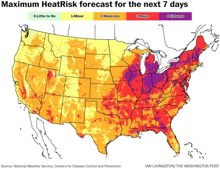
The Federal Government’s new heat risk forecast highlights the dangers to people’s health and indicates the possibility of widespread severe to extreme impacts. Level 4, or extreme heat risk, will affect parts of 12 states. Level 3, or severe heat risk areas are expected over a wider area.
Cities from Chicago to Cincinnati in the Midwest and from Philadelphia to Atlanta in the East are expected to reach Level 4 within the next week.
“This level of rare and prolonged heat, with little or no relief at night, can be detrimental to everyone without effective cooling and adequate hydration,” the weather service wrote.
Where are there heatstroke warnings?
Heat watches and warnings are in effect from the lower Great Lakes Basin and Ohio Valley through much of the northern Mid-Atlantic, New England and Maine. About 70 million people are under these heat warnings.
Extreme heat warnings are in effect through Friday for Detroit and Flint in Michigan, Fort Wayne and Marion in Indiana and Defiance in Ohio, where temperatures are expected to rise to 95 to 100 degrees, with the heat index, which takes into account humidity, reaching around 105 degrees.
Heat warnings have been issued for most, if not all, of Ohio, Pennsylvania, New York, Vermont, Massachusetts, Connecticut and New Jersey.
Extreme heat watches have also been issued for parts of the region, including Hartford, Connecticut, Philadelphia and the Boston metropolitan area north into southeastern Maine.
Where is the hottest?
East of the Mississippi River, the hottest weather will initially be concentrated in the Ohio Valley and western Pennsylvania. Temperatures will be in the low to mid 90s on Tuesday, rising to near 100 on Friday and Saturday.
Areas from northern Kentucky through the lower Mid-Atlantic are expected to see the hottest temperatures over the weekend, with highs in the 90s to near 100 degrees.
Where is the most extreme heat?
Through Thursday, areas from the Great Lakes to Pennsylvania and New England will experience unusually hot weather. Over the weekend, the area will move south to include much of the Midwest and Mid-Atlantic.
Temperatures in Maine on Wednesday afternoon are expected to be 20 to 25 degrees above normal.
The weather service serving the Portland, Maine, area said the heat expected from Tuesday through Thursday would be the hottest since July 2011, while the weather service serving Burlington, Vermont, said Montpelier could see its hottest weather in 30 years on Wednesday.
What records will be set?
Dozens of record-breaking heat waves are possible each day through the weekend, with afternoon highs reaching the 90s to near 100 degrees Fahrenheit and overnight lows reaching the 70s to near 80 degrees Fahrenheit.
Among the many calendar records that could be achieved over the weekend are:
- Syracuse, New York, Tuesday: A high of 96 degrees is expected, potentially marking a second consecutive record high temperature.
- Millinocket, Maine, Wednesday: A forecast of 97 degrees will surpass the record of 95 degrees.
- Thursday, Manchester, New Hampshire: A forecast of 99 would beat the previous record of 98.
- Philadelphia on Friday: Temperatures will be around 100 degrees and could break or surpass the 99-degree record.
- Charleston, West Virginia, Saturday: The high temperature is expected to be 97 degrees, close to the record of 98 degrees.
- Washington on Sunday: A high of 97 degrees is expected in the nation’s capital, close to the high of 98 degrees for the day.
Locations where high temperatures will be rare but could see multiple single-day records broken include Pittsburgh, Hartford, Bangor, Maine, the greater Boston area and parts of the Appalachian Mountains.
How hot has it gotten already?
Though the heatwave only began on Monday, it still produced some impressive readings. In Ohio, temperatures soared to 99 degrees in Toledo. Across the region, multiple daily records for maximum temperatures were broken.
Notable records include:
- Toledo recorded a record high of 99, beating the previous records of 97 recorded in 1957 and 1994.
- Chicago recorded a high of 97 degrees, beating the previous records of 96 degrees recorded in 1887 and 1957.
- Cleveland recorded a high of 96, surpassing its 2018 record of 94.
- Syracuse’s highest mark was 94, beating the 93s recorded in 1952 and 1994.
- Milwaukee’s highest score was 94, tying its 1994 record of 94.
Numerous new record low temperatures were also recorded in the same region on Monday.
The extreme north, which experienced scorching heat through midweek, will see some relief this weekend and into early next week as a cold front moves through, which may result in a few days of closer to normal temperatures rather than a sustained drop in temperatures.
In the South, the heat could ease slightly early next week, with temperatures likely to return to more normal early-summer levels.
As June ends and July begins, the most reliable computer weather models are predicting hotter than normal weather for most of the country.
Is climate change making this worse?
Global temperatures have been at record levels for the past year due to El Niño and human-induced warming. With El Niño disappearing and La Niña taking over, global temperatures should drop somewhat in the coming months.
The Climate Change Index from Climate Central, a science communication organization based in Princeton, New Jersey, suggests that human-induced climate change has made this week’s record heatwave at least 1.5 to 2 times more likely.

